|
|
|
Chart's # |
Chart's Name |
Chart's Scale |
| Cruising Guides to Caribbean | From BookHarbour.com | |
| CRPACK | 62 charts in BSB 2.0 format. |
€ 30.00 Buy Now |
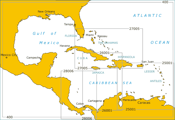
| 108 | South East Coast of North America incl. Bahamas & Antiles | 1:3 500 000 |
| 400 | West Indies | 1:4 250 000 |
| 26001. | Caribbean Sea. Central Part | 1:1 300 000 |
| 28006 | Caribbean Sea. South West Part. | 1:1 200 000 |
| 27005 | Caribbean Sea. Key West to San Juan | 1:1 500 000 |
| 25001. | Caribbean Sea. Eastern Part. | 1:1 300 000 |
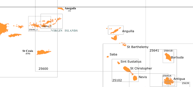
| 25600 | Anegada Passage with adjacent Islands | 1:250 000 |
| 25640. | Puerto Rico and Virgin Islands. | 1:326 856 |
| 25641 | Virgin Islands. St. Thomas to Virgin Gorda | 1:100 000 |
| 25640A | Virgin Islands. St. Thomas to Tortola. | 1:100 000 |
| 25640B | Virgin Islands. St. John to Virgin Gorda | 1:100 000 |
| 25640C | Virgin Island. Virgin Gorda to Anegada. | 1:100 000 |
| 26541_1 | Tortolla. Road Harbour. | 1:12 500 |
| 25641_2 | Tortolla. Road Harbour to Hedges Creek. | 1:12 500 |
| 25640_3 | Sir Francis Drake Channel. Western Part. | 1:35 000 |
| 25640_4 | Sir Francis Drake Channel. Eastern Part. | 1:35 000 |
| 25640_5 | Virgin Gorda. Gorda Sound. | 1:12 500 |
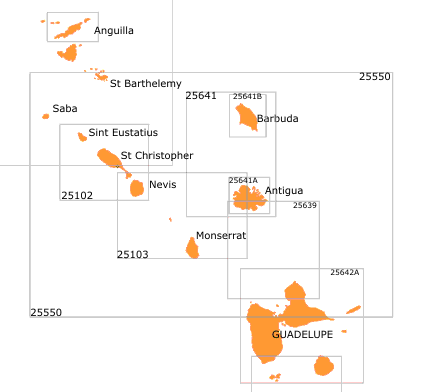
| 25100 | Sombrero to St.Barthelemy | 1:175 000 |
| 25101 | Anguilla | 1:50 000 |
| 25101_1 | Anguilla to St. Martin. Anguilla Channel. | 1:50 000 |
| 25101_2 | Anguilla. Road Bay. | 1:15000 |
| 25101_3 | Anguilla. Dog Island. | 1:50000 |
| 25102 | St. Eustatius to Nevis | 1:175 000 |
| 25102_1 | St. Barthelemy. Port de Gustavia | 1:15 000 |
| 25103 | Nevis to Monserrat and Antigua | 1:175 000 |
| 25400 | St. Vinsent to Trinidad | 1:250 000 |
 |
||
| 25550 | St. Bartelemy to Guadeloupe | 1:250 000 |
| 25550_1 | Saba Island | 1:175 000 |
| 25639 | Antigua to Guadeloupe | 1:175 000 |
| 25551 | Barbuda to Antigua | 1:175 000 |
| 25551_A | Antigua | 1:60 000 |
| 25551_B | Barbuda | 1:60 000 |
| 25551_2 | Antigua. Falmouth and English Harbours | 1: 20 000 |
| 25551_3 | Antigua. St. John's Harbour | 1:25 000 |
| 25551_4 | Antigua. Parham Harbour | 1:25 000 |
| 25642 | Guadelupe, Les Saintes to Dominica | 1:175 000 |
| 25642_1 | Guadelupe. Pointe-a-Pitre and approaches. | 1:17 500 |
| 25642_2 | Les Sainte. | 1:17 500 |
| 25642_3 | Guadelupe. Grande Terre. Petit Havre. | 1:15 000 |
| 25642_4 | Guadelupe. Grande Terre. Saint-Francois | 1:10 000 |
| 25642_5 | Guadelupe. Grande Terre. Sainte-Anne and Anse Accul | 1:10 000 |
| 25642_6 | Guadelupe. Basse-Terre. Basse-Terre | 1:15 000 |
| 25642A | Guadeloupe, Les Sainte and Marie-Galante | 1:175 000 |
| 25643 | Dominica to Martinique | 1:175 000 |
| 25643_1 | Martinique. Pointe du Precheur to Pointe des Negres. | 1:75 000 |
| 25643_2 | Martinique. Pointe des Negres to Pointe du Salines. | 1:75 000 |
| 25643_3 | Martinique. Baie de Fort-de-France | 1:25 000 |
| 25644 | Martinique to Saint Lucia | 1:175 000 |
| 25644_1 | Saint Lusia. Port Castries. | 1:5 000 |
| 25644_2 | Saint Lusia. Marigot Harbour. | 1:5 000 |
| 25644_3 | Saint Lusia. Sufriere Bay, Anse de Piton | 1:60 000 |
| 25644_4 | Saint Lusia. Vieux Fort Bay. | 1:20 000 |
| 25645 | Saint Lucia, St. Vincent to Bequia | 1:175 000 |
| 25649 | Bequia to Ronde Island | 1:175 000 |
| 25649_1 | Grenadines. Island Bequia. | 1:60 000 |
| 25649_2 | Grenadines. Mustique Island. | 1:25 000 |
| 25646 | The Central Grenadines | 1:60 000 |
| 25646_1 | Carriacou. Hillsborough Bay. | 1:25 000 |
| 25647 | Ronde Island to Grenada | 1:175 000 |
| 25648 | Grenada | 1:175 000 |
| 25658 | Barbados | 1:100 000 |
| 25659_2 | Bridgetown and Approaches. | 1:12 500 |
|
|
|
Copyright ©1yachtua.com 1998-2022 |